In response to calls at the Second World Climate Conference (Geneva, 1990), the IOC formed the Global Ocean Observing System (GOOS) in 1991. The creation was the result of an international desire to help improve forecasts of climate change, management of marine resources, mitigation of the effects of natural disasters, and use and protection of the coastal zone and coastal ocean. The call to create and develop a GOOS was reinforced in 1992 at the UN Conference on Environment and Development in Rio de Janeiro. In the 1990s, oceanic sampling needs were developed and Essential Ocean Variables (EOVs) were established. The Global Climate Observing System (GCOS) determined EOVs to include sea surface and subsurface temperatures, salinity, sea level, sea ice, currents, nutrient and carbon dioxide concentrations, ocean colour and phytoplankton distribution. Since the creation of GOOS in 1991, it is has now become a global network of ships, buoys (fixed and drifting), subsurface floats, tide gauges and satellites that collect real time data on the physical and the biogeochemical profile of the ocean. GOOS is now sponsored jointly by the IOC, the World Meterological Organization (WMO), the UN Environment Programme (UNEP) and the International Science Council (ISC).
At the OceanObs'09 conference, participants called for a Framework for Ocean Observing for an enhanced global observing system with existing and new physical, biogeochemical, and biological observations. The Framework includes:
- A multinational Steering Group to provide oversight to GOOS
- 13 regional alliances, of which the UK sits under EuroGOOS
- UK Contacts:
- Elizabeth Bradshaw (NOC)
- Veronique Creach (Cefas)
- Andrew Saulter (UK Met Office)
- UK Contacts:
- 3 GOOS Expert Panels who identify and develop EOVs, coordinate observations and promote data standards relative to their thematic area
- The Ocean Observations Physics and Climate (OOPC) Panel brings together GOOS, GCOS and the World Climate Research Programme (WCRP)
- UK Contact: Matthew Palmer (Met Office)
- Biogeochemistry Panel (represented as International Ocean Carbon Coordination Project (IOCCP) Scientific Steering Group)
- UK Contact: Maribel I. García-Ibáñez (UEA)
- Biology and Ecosystems Panel
- UK Contact: None
- The Ocean Observations Physics and Climate (OOPC) Panel brings together GOOS, GCOS and the World Climate Research Programme (WCRP)
- UK National Focal Point for GOOS: Jason Holt (NOC)
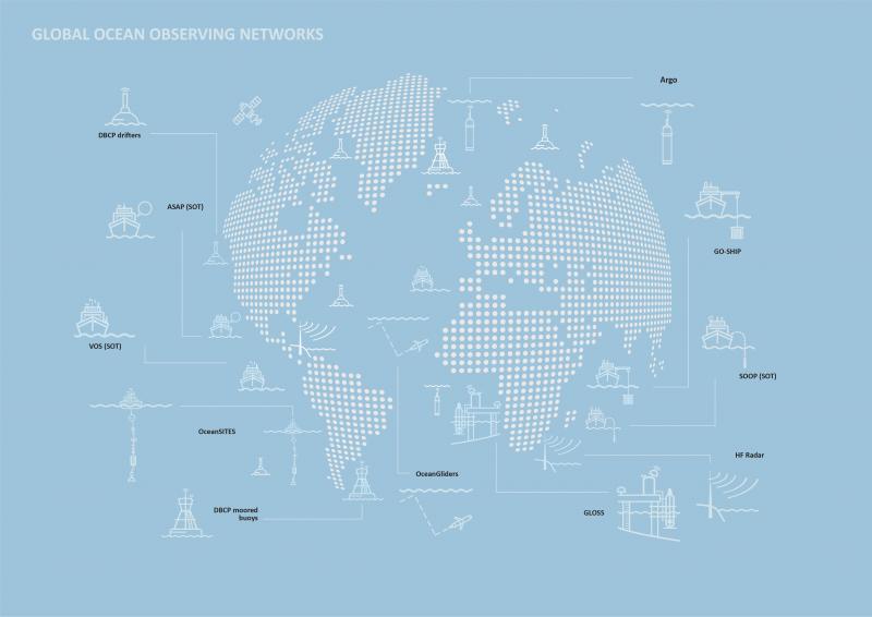
There are a number of Regional (Basin-scale) observing systems that also contribute to GOOS, of particular interest here are:
- Atlantic Observing System (AtlantOS)
- UK Contact: Penny Holliday (NOC)
- Southern Ocean Observing System (SOOS)
- UK Contact: Andrew Meijers (BAS)
At the 33rd IOC Assembly in 2025, the resolutions adopted included one for a strengthened Global Ocean Observing System (GOOS) governance model.
UK involvement
The UK supported the Global Ocean Observing System 2030 Strategy and has support of GOOS with its own investment - for example £24m over a period of 5years through the Climate Linked Atlantic Sector Science (CLASS). This provided underpinning national capability to support several UK contributions to open ocean GOOS including: GO-SHIP Repeat Hydrography, an OceanSites Multi-disciplinary Observatory in the Porcupine Abyssal Plain, the South Atlantic tide gauge network, core and deep Argo, and part of ongoing observations of the Atlantic Meridional Overturning Circulation.
| GOOS Projects and the UK Contributions | ||||
|---|---|---|---|---|
| Project | Description | UK Involvement | Point of Contact | Organisation |
| Observations Coordination Group (OBC) | The Observations Coordination Group (OCG) reviews, advises on, and coordinates across the global ocean observing networks to strengthen the effective implementation of a GOOS. The vision for OCG is to contribute towards a fit-for-purpose, integrated, and coherent ocean observing system that supports 1) a rapidly expanding set of weather, climate, marine and ocean services targeting stakeholders across the globe; 2) a vibrant international research community developing knowledge and solutions for the next decade. | The vice-Chair is represented by the Met Office. | Jon Turton | Met Office |
| Argo is a partnership of over 30 nations bringing together an array of 3500 inter-calibrated, profiling floats. These measure temperature and salinity as they descend to 2000 m, before ascending to 1000 m where the float drifts for around 9 days, before ascending to the surface and transmitting the data. | The UK has been a member of Argo since it began in 2000 and has deployed over 300 floats in the Indian, Atlantic and Southern Oceans and is fully committed to helping to maintain the global array of floats. BEIS is a formal partner in Euro-Argo, with the BODC, Met Office, PML and NOC being contributing/representing entities. An extension of Argo is the Biogeochemical (BGC)-Argo programme, focussing on core variables to measure such as oxygen, nitrate, pH, Chl-a, suspending particles, downwelling irradiance. The UK Bio-Argo programme is largely funded through NERC and the Met Office. Project partners include PML, Met Office, NOC and BODC. The area of interest is the North Atlantic sub-polar gyre, sub-tropical gyres and oxygen minimum zones. | Brian King | NOC | |
| Fiona Carse | Met Office | |||
| Jon Turton | Met Office | |||
 | The Data Buoy Cooperation Panel (DBCP) is an official joint body of the World Meteorological Organization (WMO) and the IOC. The primary objective of the DBCP is to maintain and coordinate all components of the network of over 1250 drifting buoys and 400 moored buoys, which provide measurements such as sea surface temperature, surface current velocity, air temperature and wind speed and direction. | The UK has a variety of moored buoy programmes:
Other than the Cefas-managed buoys (data available via their website), the buoys report data via the Global Telecommunications System. The Met Office also has 28 drifters buoys as part of the DBCP Global Drifter Program. These are primarily in the South Atlantic. They also have 12 drifer buoys under the AOML Global Drifer Program/EUSURFMAR - these primarily target the North Eastern Atlantic. | David Knott | Met Office |
| Expert Team on Operational Ocean Forecasting System (ETOOFS) | The Expert Team on Operational Ocean Forecasting System (ETOOFS) manage and maintain the guide, scope and requirement documents, adhering to relevant Quality Management Systems, for Member States providing ocean forecasting services - this portfolio ranges from ocean physics to biogeochemistry. | None | N/A | |
The Global Alliance of Continuous Plankton Recorder Surveys (GACS) was formed in 2011 to create an international network of 13 continuous plankton recorder (CPR) surveys. CPRs are instruments usually towed from ships to capture plankton, the data are then analysed to study phytoplankton, zooplankton and calculate phytoplankton colour index. This data is helpful for understanding physical, biological and chemical changes in the environment. GACS has increased its engagement with the SOOP International Panel and the FerryBox programme (under EuroGOOS). | The UK has a long history in CPR surveys with the first CPR prototype being designed and used in the Antarctic by Sir Alister Hardy in the mid 1920s. In 1931 the first CPR tow in the North Sea took place and data has consistently been recorded there since then. The core CPR sampling focuses in the North Atlantic and northwest European shelf. The CPR survey, headed by David Johns, merged with the Marine Biological Association (MBA) in 2018. | Claire Ostle | CPR Survey | |
The Global High Frequency Radar (HFR) Network was established at the 8th Plenary of the Group on Earth Observations (GEO) in 2011. The primary aim of the Global HRF Network is to create a global operational system measuring ocean surface currents using high frequency radar in order to support marine and coastal ecosystems. | The University of Plymouth owns and operates a high-frequency ocean Wellean radar system to measure surface currents and directional wave spectra on the north Cornwall coast. Prof Lucy Wyatt is Co-Chair of the Global HFR Network and a member of the EuroGOOS HFR Task Team. | Lucy Wyatt | University of Sheffield | |
 | Ship-based hydrography is essential for documenting ocean changes throughout the water column, especially for the deep ocean below 2 km where floats/gliders are currently able to reach. Global Ocean Ship-Based Hydrographic Investigations Programme (GO-SHIP) coordinates a network of globally sustained hydrographic sections as part of the global ocean/climate observing system where expeditions take place every decade and cover ocean basins from coast to coast and sample the full water column. This allows for changes in inventories of heat, freshwater, carbon, oxygen, nutrients and transient tracers to be identified. The GOOS Expert Panel on Biogeochemistry (IOCCP) is heavily involved with GO-SHIP. | In 2020 an international research expedition led by scientists from the NOC conducted a survey along 24.5°N of the North Atlantic as part of the GO-SHIP program and funded by NERC’s Climate Linked Atlantic Sector Science (CLASS). | Yvonne Firing | NOC |
The Global Sea Level Network (GLOSS) is a joint IOC-WMO venture, first established in 1985 to establish an in situ sea level observing network to support a broad research and operational user base. GLOSS contributes to GOOS, particularly its climate, coastal and operational service modules, through development of the sea level measurement network, data exchange and collection systems, and preparation of sea level products for various user groups.
| The UK has 3 tide gauges from the UK Tide Gauge Network, 6 tide gauges in the British Dependent Territories of the South Atlantic and Gibraltar and 2 gauges in the Antarctic. In the UK the Permanent Service for Mean Sea Level (PSMSL) at NOC is responsible for the collection, publication, analysis and interpretation of sea level data from the global network of tide gauges, including the GLOSS Core Network. The GLOSS Delayed Mode Data Centre is operated by the British Oceanographic Data Centre (BODC) in collaboration with PSMSL and has responsibility for assembling, quality controlling and distributing the “final” version of GLOSS sea-level data sets, as well as all supporting metadata information. | Elizabeth Bradshaw | BODC at NOC | |
 | The International Ocean Carbon Coordination Project (IOCCP) promotes the development of a global network of ocean carbon observations for research through technical coordination and communication services, international agreements on standards and methods, and advocacy and links to the global observing systems. | More information on how the UK is involved with IOCCP can be found on the separate UK-IOC IOCCP activity page. | None | N/A |
 | The Marine Mammals Exploring Oceans Pole to Pole (MEOP) consortium is an umbrella for a number of regional and national programmes regarding animal-borne instruments (ABIs). Given the depths and breadth marine mammals travel, the use of tagging and instruments allows for data such as temperature, salinity and behavioural characteristics to be recorded. Over half a million vertical temperature and salinity profiles have been recorded since 2004 through ABIs. | An ABI task team exists within EuroGOOS and acts as the European component within MEOP. The Chair of the ABI task team is Lars Boehme of the Seal Mammal Research Unit (SMRU). The SMRU develops instruments that attach to the seals to record ocean variables and animal behaviour. Data is submitted to the Global Telecommunications System automatically. BODC are also been involved with quality control of ABI data. | Several UK contacts | SMRU, University of St Andrews; MASTS; BAS; UEA |
 | Gliders are autonomous underwater vehicles that transect the water column from the surface to up to 2000 m depth in a saw-tooth trajectory. While gliders have been used for the last 20 years, the OceanGliders programme was only formed in 2016. The primary aims being to observe physical, biogeochemical and biological ocean processes that are relevant for societal applications, and to contribute to the GOOS real-time and delayed mode data. | The UK has three institutes with gliders: the National Oceanography Centre, the University of East Anglia and the Scottish Association for Marine Science. The UK is also represented within the following Task Teams: Boundary Currents, Water Transformation, Best Practices, Data Management. BODC is an OceanGlider data Assembly Centre (DAC) for UK glider deployments. | Filipa Carvalho | NOC |
| Marie Porter | SAMS | |||
 | OceanSITES provides a global network of fixed-point instruments to measure various physical, biogeochemical, ecosystem and atmospheric variables. The programme objective is to build and maintain a multidisciplinary global network for a broad range of research and operational applications including climate, carbon, and ecosystem variability and forecasting and ocean state validation. | The UK contributed two sustained observatories to the OceanSITES program; the Northern Oligotrophic Gyre (NOG) and the Southern Oligotrophic Gyre (SOG), which were two of the only three sustained observatories in the vast oligotrophic gyres of the ocean. However, in 2020 these were terminated due to lack of funding. | Richard Lampitt | NOC |
| The Ship Observations Team (SOT) has been running for over 100 years and is split into two areas:
These data support research, climate forecasting, weather predictions and maritime safety services. | There is no formal SOOP programme in the UK, though BAS does act as a focal point for SOOP. The UK has around 300 VOS, where over 70,000 data observations were submitted to the Global Collecting Centres and 1,179,312 observations distributed on the Global Telecommunications System. The VOS come from research organisations, military and industry. 60 of the ships have been fitted with a Met Office built Autonomous Marine Observing System. Under EuroGOOS, a task team has been set up to create the FerryBox system for VOS/SOOP. UK institutes developing, operating or applying FerryBox systems are NOC, Cefas, SEPA and Marine Scotland. | Elizabeth Kent | NOC |
| Emma Steventon (SOT, VOS, ASAP) | Met Office | |||
| Steve Colwell (SOOP) | BAS | |||