Campaign Activities
Find out more about our Campaign Activities
to measure, for the first time, two-dimensional fields of total surface current and wind vectors at 1-km resolution, with high accuracy, over all coastal seas, shelf seas and MIZs, to characterise their magnitude, spatial characteristics, regional extent, and temporal variability on daily, seasonal to multi-annual time scales
to deliver, for the first time, accurate high-order derivative products (e.g. vorticity, strain, divergence) to explore the relations between ocean sub-mesoscale/mesoscale circulation, air-sea fluxes and vertical exchanges
to investigate the relations between small-scale dynamics, air-sea interactions, vertical processes and marine productivity using synergy with high-resolution satellite data from optical, thermal and microwave sensors
to validate high-resolution and coupled models and support the development of new parameterisations to improve operational forecasts and reduce uncertainties in climate projections.
SEASTAR consists of a single instrument on a single satellite flying in sun-synchronous Low-Earth Orbit. SEASTAR is the first single-platform SAR (synthetic-aperture radar) system dedicated to squinted along-track ocean interferometry from space.
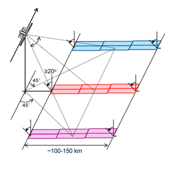
The payload features two squinted SAR beams pointing ±45° in azimuth fore and aft of the satellite plus a standard SAR beam broadside with multi-polarisation capability (VV/VH, HH/HV). This innovative approach makes it possible to retrieve both components of the ocean surface current vector and the wind vector simultaneously in a single pass, with fine resolution and high accuracy.
SEASTAR produces a single-sided continuous swath 100–150km wide with a minimum incidence angle of 20°. The inherent spatial resolution of the SAR images is a trade-off between observing swell waves and achieving high accuracy Level 2 products for ocean surface current vectors and wind vectors at 1-km resolution over the full swath. Scientific objectives are traced to high accuracy requirements at 1-km resolution for TSCV (0.1ms−1) and OSVW (1ms−1).
The instrument operates at Ku-band or Ka-band. The choice of microwave frequency and interferometric baseline must ensure high sensitivity across the wide swath in all sea state conditions, including sheltered coastal regions.