Submarine landslides and tsunamis
Why are landslide generated tsunamis dangerous?
Severe landslide tsunami impact is most often local, but for extreme landslide events the tsunami impact can be regional. A tsunami generated by a landslide has a shorter period with stronger currents and fluxes than tidal waves or storm surges, even for the same run-up height. The tsunami wave can inundate otherwise sheltered areas unlike wind waves or swells. Landslides generating shorter tsunamis can favour amplification.
The process that causes such tsunamis – submarine landslides – may occur along many continental margins, also on very gentle slopes of as low as 1º. Along the UK coastline and in many other places it is therefore the submarine landslide hazard that controls the local tsunami threat. However, landslide-tsunamis are not accounted for in most tsunami hazard assessments. This is because of large uncertainties involved with the current scientific understanding of submarine landslides. Societies are not prepared and a landslide tsunami is likely to have extreme consequences.
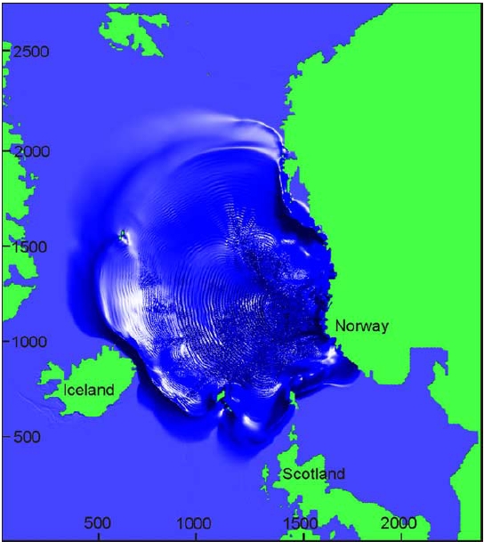
It has been suggested that environmental changes driven by changes in climate could cause instability at continental margins, and increase the landslide frequency. Changes in water temperature or pressure regime (through sea level changes) causes otherwise stable gas hydrate to dissociate. The reduction of weight on continents due to melting ice sheets causes the Earth’s crust to rebound accompanied by large earthquakes. Both gas hydrate dissociation and earthquakes have the potential to cause submarine landslides. The Arctic is one of the planet’s regions that is affected most by modern climate change, and tsunamis caused by landslides along the Norwegian or East Greenland continental margins could have devastating consequences for the UK. Specific questions that we aim to answer are:
What is the recurrence interval of submarine landslides?
A robust chronological framework that documents the timing and frequency of submarine slides in the Norwegian-Greenland Sea is a prerequisite for estimating slide recurrence interval in the future. We determine the timing of large landslides at the Norwegian continental margin using sediment cores that are retrieved from research vessels. This allows us to estimate the landslide frequency in the last 20,000 years. Our fieldwork gives an impression of how to determine the age of a landslide.
Past tsunamis on the UK coastline?
Not every submarine landslide in the Arctic region causes a tsunami that reaches the UK coastline. To better constrain which landslides did and which did not generate tsunamis we compare the timing of large landslides at the Norwegian continental margin to a tsunami chronology. Click here for explanation on how such tsunami chronology is established.
Does every submarine landslide cause a tsunami?
It is important to understand which slides generated tsunamis, and why. Therefore, in a first step we compare ages of large landslides at the Norwegian continental margin to tsunami chronology. Subsequently, we reconstruct how submarine landslides that did cause tsunamis were emplaced.
Is the landslide frequency likely to increase?
Earthquakes can trigger submarine landslides. Although the Arctic is not an earthquake ‘hot spot’ at the moment, this may change. Seismicity is likely to increase due to the melting of ice sheets. We use models to get to know locations of future earthquake hot spots.
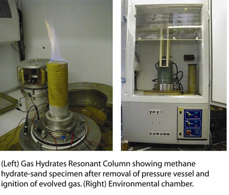
Gas hydrates have a stabilising effect on marine sediments at continental slopes. But what happens when these hydrates dissociate due to temperature or pressure changes? Conducting geotechnical laboratory experiments we aim to increase understanding of how methane hydrate dissociation influences the engineering properties of marine sediments.
With the help of computer models we analyse how the continental slopes will react to earthquakes and gas hydrate dissociation.
What is the likely impact of a landslide-tsunami from the Arctic to the UK?
Predicting how a tsunami might impact the UK is not easy. Previous deposits and tsunamis elsewhere help inform what might happen, but a useful tool is numerical modelling. We have developed and advanced numerical modelling tool, Fluidity, that can simulate landslides and the resulting tsunami. We use an unstructured mesh that allows a smooth representation of coastlines and bathymetry. In addition, it allows high detail in areas of interest with lower resolution elsewhere, minimising computational expense. One of the advanced features of Fluidity is the ability to change this resolution as the simulation proceeds. This is extremely valuable when simulating landslide which requires high detail to be captured around the slide, but this detail needs to move with the slide. The video shows an example of how the propagation of a tsunami wave can be modelled.