Greenland melting - where does the freshwater go?
The rate of Greenland melting has been accelerating in the past 2 decades. Not only is Greenland releasing more freshwater into the oceans, it's doing so to a greater extent each year. However, due to how the ocean circulation responds to the Earth's rotation in high latitudes, that freshwater is mostly "trapped" on the shallow (500 m deep) shelves around Greenland, in the boundary currents circulating from east to west around the southern tip of Greenland, and cannot escape to the open ocean where convection occurs.
There are a few hypotheses about how and where freshwater can break through these boundary currents - where one candidate mechanism is through eddying of the boundary current, where the boundary current goes unstable due to roughness in the bathymetry and spins out little whirling vortices of water carrying the signature of the boundary current in their temperature and salinity structure (cold and fresh at the surface, warm and salty below).
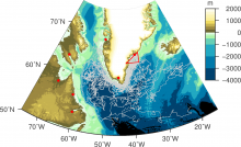
Due to the sporadic and spatially distributed areas where this escape can occur, typical fixed location monitoring strategies cannot be used. Instead, surface drifters (small, GPS-tagged floating buoys can be used to follow the paths of freshwater at the surface, transmitting their locations via satellite every few hours. The Global Drifter Program releases hundreds of drifters throughout the world's oceans to study the surface circulation, but only a few of these arrive on the shelves around Greenland to track where waters go. Using available drifter tracks (shown by grey lines in the figure) we can 'tag' the ones that cross through the red triangle, off the southeast coast of Greenland and see where they end up. But with only 50 drifters crossing through this region since the 1990s, there are too few to determine with statistical confidence the processes responsible for their eventual escape from the boundaries. In TERIFIC, we will release large numbers (~200) drifters directly into the study region to investigate where and how freshwater from Greenland (and the Arctic) can make its way into the open ocean.